

Nature’s dams on the Klamath River blocked fish for millennia
Why is the natural lava dam that has been in place since creation overlooked?
In 1911, when the famous engineer and dam-builder J.C. Boyle arrived at Wards Canyon to build Copco 1 dam, he noted the existence of the 31-foot-tall natural lava dam that held back Clammittee Lake.
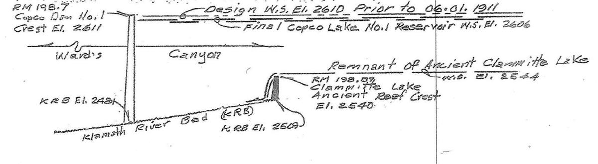
J.C. Boyle made a detailed drawing of that 31-foot-tall lava dam and its lake (Clammittee Lake). That drawing was published in 1913 and that image is associated to this article for reference in Fig. 3. Figure 3 shows the flow of the Klamath River over the top of that natural lava dam, the riverbed and the location of Copco 1 dam a quarter-mile downriver.
Below: https://www.capitalpress.com/opinion/columns/commentary-natures-dams-on-the-klamath-river-blocked-fish-for-millennia/article_57cf799a-1724-11ec-9256-b78d887a7c2c.html
Commentary: Nature’s dams on the Klamath River blocked fish for millennia
- By WILLIAM E. SIMPSON III
- Sep 16, 2021
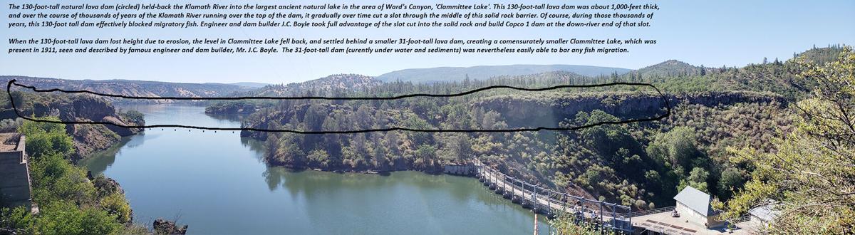

Numerous published geologic studies and present-day observations show that over the course of past millennia, a series of no less than five lava flows crossed the Klamath River.
At least two of these lava flows dammed the Klamath River at Wards Canyon.
These lava flows, which dammed the Klamath River, are also called “reefs” or “dikes” by geologists. These lava flows formed tall dams that without doubt blocked fish migration for millennia. (See Fig. 1)
One of those five dams was 130 feet tall off the riverbed and was 1,000 feet thick! (See Fig. 2)
The slot that was eroded-through the 1,000-foot thick, massive 130-tall lava dam is seen in image Fig. 2. The modern dam, Copco 1, was built in the downriver end of the slot, and can also be seen in the drone photo (Fig. 2).
This 130-tall natural lava dam on the Klamath River formed a large lake called Clammittee Lake that was five miles long and one mile wide.
Over the course of thousands of years, the Klamath River finally cut a narrow notch down through this massive natural lava dam. And as the water level in Clammittee Lake fell, the Klamath River eventually ended up being held back by a smaller 31-foot-tall lava dam a quarter-mile upriver, which maintained a smaller version of Clammittee Lake through 1911 and the completion of Copco 1 dam.
In 1911, when the famous engineer and dam-builder J.C. Boyle arrived at Wards Canyon to build Copco 1 dam, he noted the existence of the 31-foot-tall natural lava dam that held back Clammittee Lake.
J.C. Boyle made a detailed drawing of that 31-foot-tall lava dam and its lake (Clammittee Lake). That drawing was published in 1913 and that image is associated to this article for reference in Fig. 3. Figure 3 shows the flow of the Klamath River over the top of that natural lava dam, the riverbed and the location of Copco 1 dam a quarter-mile downriver.
J.C. Boyle took advantage of the slot cut through the 30-foot-tall lava dam that was a quarter-mile downriver from the smaller 31-foot-tall lava dam.
At farthest downriver end of that slot, J.C. Boyle integrated his new dam (Copco 1) into the solid rock that was part of Nature’s massive lava dam.
The resulting modern dam was nearly as tall as the original natural 130-foot-tall dam, and brought the water level in Clammittee Lake back up to where it had been thousands of years before, restoring that ancient lake to its full glory where a myriad of unique species of flora and fauna had evolved and remain present today.
Today, Clammittee Lake is within the present footprint of Copco Lake, which is situated behind Copco 1 Dam. Copco lake alone holds 25 billion gallons of fresh water.
The foregoing evidence belies the premise argued by dam removal proponents that fish from the lower Klamath River basin had allegedly migrated past Wards Canyon.
Rock solid evidence, geology, proves that is a false premise.
William E. Simpson II is a naturalist studying the wildlife in the area around the Klamath dams. He is the author of two published books and more than 100 published articles on subjects related to wild horses, wildlife, wildfire and public land management.
====================================================
In accordance with Title 17 U.S.C. section 107, any copyrighted material herein is distributed without profit or payment to those who have expressed a prior interest in receiving this information for non-profit research and educational purposes only. For more information go to: http://www.law.cornell.edu/uscode/17/107.shtml
- Writing Classes and Contests – John SammonPost Views: 112 By John Sammon “My advice if you’re thinking about taking a writing class in an effort to become a novelist or entering a writing contest is—-let the buyer beware.” I have to admit I am not a fan of either. First of all, often enough both will cost you money, a class
- Loose Screws: Mount Shasta Leadership Shakeup Leaves Questions UnansweredPost Views: 942 By J.A. MartinSiskiyou News Mount Shasta City Council took swift action on July 8: placed City Manager Todd Juhasz on indefinite paid administrative leave and replaced City Attorney John Kenny with interim attorney Andrew Jared of Colantuono, Highsmith & Whatley, PC. At the July 13 meeting, Mayor Casey Glaubman cited fiduciary duty and legal restrictions: the council cannot publicly discuss employment or
- Protecting Your Health During A Wildfire : What Northern California Residents Should KnowPost Views: 111 By: Dr. Dinelli Monson, Chief Medical Officer, UnitedHealthcare Employer & Individual Plans of California A wildfire can change daily life quickly in Northern California when residents face smoky skies, reduced air quality, and the possibility of evacuation during periods of elevated wildfire activity. While conditions may look different from one community to
- State Water Board To Consider LOW-INTEREST LOAN For Quartz Valley Tribe Land Acquisition In Scott River HeadwatersPost Views: 131 CWSRF financing would fund tribal land-back effort aimed at watershed restoration and salmonid habitat protection ETNA — The State Water Resources Control Board is scheduled to consider a resolution at its July 21 meeting that would authorize a low-interest loan to the Quartz Valley Indian Reservation (QVIR) to acquire and protect land in
- Obituary: Minnie “Bunny” FrederickPost Views: 64 Minnie “Bunny” Frederick died on July 10, 2026 at her home in Yreka. She was born on February 9, 1926 in CleElum ,Washington to Robert and Minnie Ballard. Bunny had two sisters: Betty and Babs, and two brothers: Chuck and Bobby, all of whom preceded her in death. Bunny had to quit
Arrest Arrested arrest report bookings California California News CHP CHSRA Copco Dam Removal Dunsmuir Dunsmuir Elementary Etna EtnaCa Irongate John Sammon Klamath National Forest klamath river Klamath River Dams KNF Law Enforcement Local Government McCloud Montague Mount Shasta Mt Shasta Northern California obituary police blotter Public Safety Salmon Scott River Scott Valley SCSO Siskiyou Siskiyou County Siskiyou County Board of Supervisors Siskiyou News Unitedhealthcare weedca Whaleback Pack wildfire wolves YPD Yreka



3 Comments
You realize there are pictures of early settlers and Native People catching salmon upstream of Wards Canyon. These lava flows were ancient structures long eroded by the time the dams were built. Either we will know soon. Copco Lake will be drained in a manner of months.
see story map that includes historical photos of salmon and steelhead being harvested upstream of Wards Cayon at https://bringthesalmonhome.org/understanding-dam-removal/#historic-salmon-runs
Bill Simpson is actually not a fisheries biologist, a geologist or a credible scientific researcher. I am sure he knows a lot about horses and flying though. Here is his bio:
Capt. William E. Simpson II: Naturalist – Author, ‘Capt. Bill’ is a retired U.S. Merchant Marine Officer; commercial airplane and helicopter pilot; Master SCUBA Diver; gemologist and university instructor (Univ. of Hawaii – Maui Campus).
Bill spent his formative years on the family working-ranch raising livestock. He also worked in forestry-logging industry in Southern Oregon. After graduating high school, he attended Oregon State University as a pre-med science major, but ultimately earned his degree in Flight Technology.
Bill currently lives at his wilderness ranch among a herd of free-roaming wild horses in the Soda Mountain wilderness area on the Oregon-California border where he studies the behavioral ecology of wild horses on wilderness landscapes and wildfire.
Bill has been a guest on several radio and TV News shows over the past 7-years. Bill is a published author with two books in print and has also authored over 150 articles on subjects related to natural resources management, with a focus on wildfire and wild horses.”
My understanding is that early on when the Klamath dam removal effort was proposed as a more cost effective way to obtain fish passage than trying fish ladders etc., Pacific Power rejected the premise that salmon and other fishes migrating upriver ever migrated all the way to the Klamath Falls area. Presumably this was based on the natural lava flow dam theory. However, dam removal proponents including the native tribes provided so much evidence in the form of photos etc. that the court rejected the premise salmon never got that far upstream and the law suit was dismissed.
A logical explanation would be that despite the lava flow natural dams were inundated at certain stream flows (probably during storm events) that allowed the determined salmon to navigate thru the dammed areas and eventually reach spawning grounds in the Klamath Falls area. So, what May have looked like real barriers to fish migration were in reality delays i.e. barriers at low flows but passable at some point during enhanced storm flow conditions.
I have seen similar situations on the upper Middle Fork Eel River above Covelo. Proof fish were able to pass was there were lots of juvenile fish in the river above them.
Hope this helps with those who doubt or distrust that salmon ever got thru.