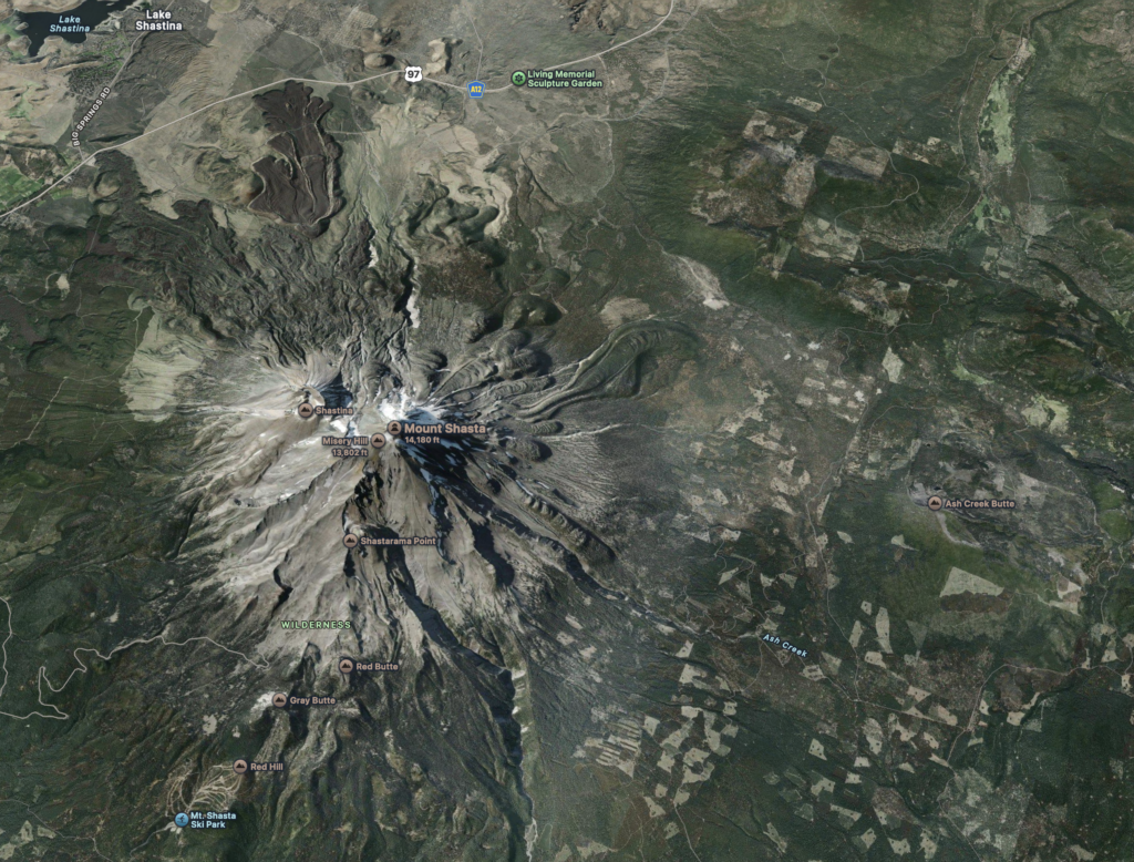
From my home in the Shasta Valley I can look to the east and count off the major Cascade peaks from left to right: Willow Creek Mountain, Ball Mountain, Goosenest, Herd Peak, Whaleback, and finally Mt. Shasta. Whoops, I missed a sharp point barely sticking up between Whaleback and Mt. Shasta—Ash Creek Butte. It lies further east and away from the straight line the other mountains form, so seems to be almost trying to hide from view. That is the mountain this article focuses on.
We are still in the dying end of the Pleistocene, or Ice Age. Glaciers persist on Mt. Shasta, the Cascades and High Sierra. It is even possible that a few hang on in the highest elevations of the Trinity Alps. Global climate change, so far, has not eliminated all these chunks of ice.
So, now, let’s bring Ash Creek Butte into the story. The mountain top is relatively high for our area, at about 8,400 feet elevation. It also lies in a heavy precipitation zone, where storms laden with moisture are pushed up from the south and west, dropping impressive amounts of rain in the lowlands and snow at higher elevations. The heavy snow zone includes Mt. Shasta, of course, as well as the peaks surrounding the upper Sacramento River and McCloud River drainages. Mt. Shasta’s bulk and location must be a major factor in wringing out frozen precipitation throughout this zone.
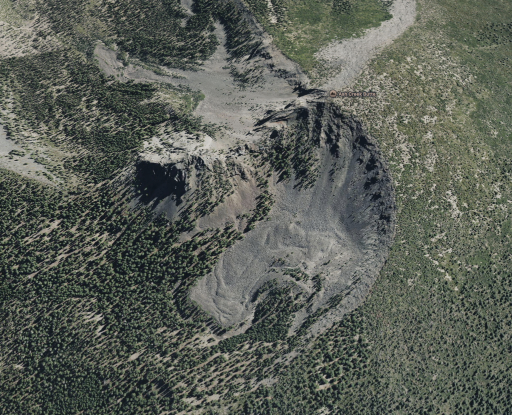
This precipitation pattern must have occurred for a very long time as most of our nearby higher mountains show evidence of past glaciation during the height of the Ice Age. During those times Ash Creek Butte had glaciers that excavated a large bowl (or cirque) on its northern slope. That excavation was responsible for the sharpened mountain peak that we can see when looking east from Shasta Valley. The Butte’s glaciers flowed northerly down the Butte Creek valley for twelve miles! The ice movement left ridges of ground-up debris along its edges (moraines) that we can see today. The glaciers extended as low as 4,800’ elevation—which indicates that Ash Creek Butte must have been received impressive amounts of snow. These flowing rivers of ice would have been an impressive sight to see!
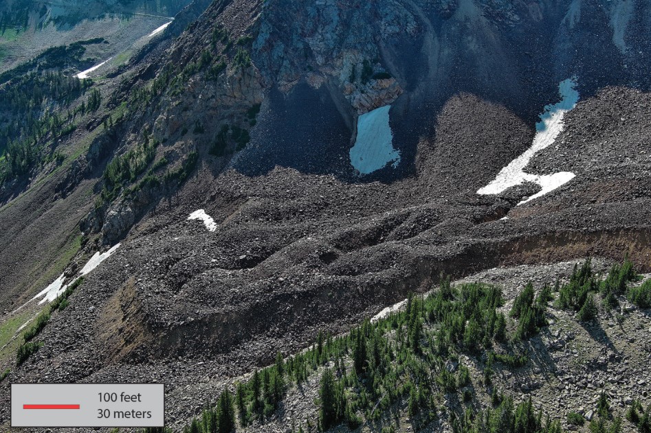
As a disclaimer, I have worked and explored all around Ash Creek Butte but have never climbed it. Now, at my age, I wish that I had! For years it has been known to shelter masses of mixed ice and rock chunks—so called “rock glaciers”. Glaciers are no longer sheltered by the mountain but through the years rocks fell on top of and mixed with patches of ice, which helped insulate the mass from summertime melting.
I have seen rock glaciers before, in the Rockies and eastern Nevada. They exist in high mountains and cold regions throughout the world and have interesting characteristics somewhere between rock piles (talus) and glaciers. Looking at them from the air they show the ridges, mounds and lobes characteristic of moving glaciers. Strangely enough, rock glaciers can move also! Recently a road built across a rock glacier in Alaska had to be realigned after the slope began to head downslope. I asked my geologist friend, who has considerable experience exploring Ash Creek Butte, if he thought it was moving. He told me that years ago he took a core out of a large tree that was growing immediately downslope of the rock glacier. The core showed that the tree was about 400 years old, so he thinks that the rock-ice feature has been stable for at least that length of time.
The geological and meteorological characteristics of the area make it unusual and special. Ash Creek Butte is one of the sites within the Klamath and Shasta-Trinity National Forests that has been given special recognition. Some of these designed special areas have unique plants or plant associations, others have geological specialness. By giving that recognition the federal land managers can better make decisions regarding how to manage these sites for their uniqueness. If you scan recent maps of these forests you will see these sites scattered throughout the landscape. All of them are worthy of us explorers to visit and ponder.
These special places seem to be perfect for research. In the case of Ash Creek Butte, research may help us understand how rock glacial persist during times of shrinking glacial ice. In some parts of the world rock glaciers are significant suppliers of streamflow during warm seasons. Does this mean that if global climate change reduces the extent of glaciers, rock glaciers may form? And, if so, might they help us out with summertime streamflow?
From my perspective the presence of Siskiyou County’s relatively low elevation rock glaciers or true glaciers gives us the opportunity to study how climate may have changed in the past and what might occur in the future. After all, our rock glaciers and glaciers are riding the fence between existing and not existing. Small changes in temperature, the amount of snow or other factors should result in changes very quickly. At least, that is how I see it. So, let’s encourage research of our local mountain ice patches and then hope that the results will be shared with us people who live in their backyard.
Explore Ash Creek Butte sometime, 41.44724° N, 122.04881° W. Check out maps to decide the best way to climb it. It will be a day of good exercise, and you will be able to tell all your friends that you saw a remnant of the Ice Age.