Public Information: (530) 238-5254
Media Inquiries: (530) 395-0326
[email protected]
www.fs.usda.gov/r05/shasta-trinity
Start Date: Tuesday, July 1, 2025
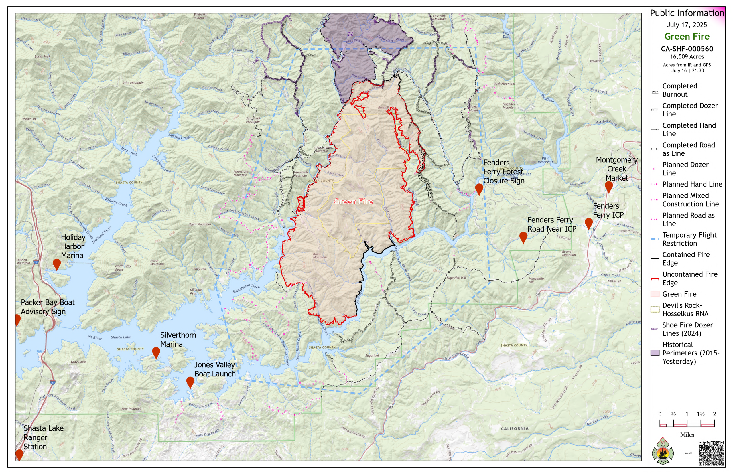
Size: 16,509 acres
Cause: Lightning
Location: Shasta County, CA.
Percent Contained: 16%
California Team 10: Joe Sean Kennedy, IC
Shasta Trinity National Forest and California Complex Incident Management Team 10 would like to acknowledge the assistance from Caltrans in getting crews and engines around the closure that occurred on Interstate 5 this morning.
The Shasta County Air Quality Management District urges that “all members of the public, especially those with respiratory or heart disease, the elderly, pregnant women, and children should remain alert, and if necessary, reduce or avoid all outdoor exertion when wildfire smoke is present.” Daily winds have had the effect of moving smoke from the Green Fire back and forth across the area affected by the fire. Local wildfire smoke information may be found at https://www.shastacounty.gov/air-quality/page/wildfire-smoke-information.
Resources: The fire currently has use of two Super Scooper aircraft; 9 helicopters, 6 of which are Type 1 airships; 5 Ambulances; 26 Bulldozers; 107 Engines; 27 Crews, 16 of which are Type I Hotshot Crews. Ten watercraft are assigned to the Pit River. A total of 1,461 individuals are assigned to the fire.
Fire Activity: Fire activity between the Sulanharas and Pit River arms of Shasta Lake remained active through yesterday evening, moving steadily to the southwest. Along the west flank, fire has reached the Brock Mountain Road, but potential remains for active fire above the road to throw or roll embers across the Brock Mountain Road. Unburned fuels in the northern most area of the fire, and between the east flank of the fire and the Rip Gut Ridge fireline, have gradually been consumed by the progression of the fire. Movement of the fire south along the east flank of the fire has nearly reached the Pit River. Fire behavior yesterday was dominated by steady movement along the ground with occasional areas of more intensive fire activity depending on topography and winds. The area of most active fire observed yesterday was in the southwestern area of the fire between the Sulanharas and Pit River arms of Shasta Lake.
Fire Weather: Predicted winds in the morning will be out of the northeast, moving smoke to the south. Winds will shift in the early afternoon, pushing smoke northward. The southern area of the fire will experience sufficient afternoon visibility to allow for aircraft operations, while limited visibility in the northern half of the fire may preclude the use of aircraft. Temperatures will remain in the low 90s, relative humidity will moderate, ranging between 20-26%. Winds will be moderate at between 5 and 8 mph out of the south in the afternoon. Persistent heat and low humidity over the last week has progressively dried fuels to such an extent that burning potential remains high in spite of moderating temperatures, humidity, and wind.
Fire Operations: The east flank of the fire along the Rip Gut Ridge fireline that extends to the Pit River, and the area to the southwest between the Sulanharas and Pit River arms of Shasta Lake, will be the focus of operations today. The southern extent of the Rip Gut Ridge Fireline is now rigged with pumps and hose lays and will receive retardant application in anticipation of firing operations to tie this fireline to the Pit River. Crews successfully conducted firing operations last night, reinforcing the southern third of this fireline. This effort is likely to require an additional day to complete before firing operations reach the Pit River. Between the Sulanharas and Pit River arms of Shasta Lake, crews, assisted by helicopters, took advantage of the southward progression of the fire yesterday to limit the progression of the fire along a portion of a road previously identified as a control feature between the two arms of the lake. In effect, they were able to begin the construction of reinforced fireline. Crews also successfully conducted firing operations last night to strengthen the construction of fireline between the arms of the lake. Crews will continue these efforts today. Air support is likely to be available again in the southern area of the fire as smoke disperses in the afternoon.
Evacuations: As of July 12, a portion of Shasta County Zone LKH-1448 has been placed under an mandatory evacuation order. All or portions of Shasta County Zones LKH-1448, LKH-1190, LKH-1200 are under an evacuation warning. Information related to evacuation zones can be found by going to https://protect.genasys.com/search. Shasta County’s emergency alert and public warning system, AlertShasta, can be found here: https://www.shastacounty.gov/community/page/alertshasta-shasta-countys-new-public-warning-system.
Closures: Shasta National Forest closure orders related to the Green Fire may be found here: https://www.fs.usda.gov/r05/shasta-trinity/alerts/green-fire-closure-order.
Additional fire-related information:
Facebook: https://www.facebook.com/ShastaTrinityNF/
InciWeb: https://inciweb.wildfire.gov/incident-information/cashf-2025-shastatrinity-lightning
Air quality: https://www.airnow.gov
Additional Information at Linktree: https://linktr.ee/shffirepio