
February 1st snow survey results for Scott River sub-basin
FOREST SERVICE NEWS RELEASE
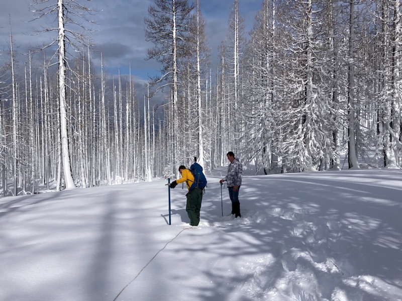
COVER PHOTO: Post-storm snow survey at Dynamite Meadow (in Middle Boulder Creek drainage). Forest Service personnel (left to right): Kip Van de Water and Matt Libby.
Credit: USDA Forest Service
YREKA, Calif., February 5, 2024— The Klamath National Forest has completed the February 1st snow surveys. These measurements are a part of the statewide California Cooperative Snow Survey program, which helps the state forecast the quantity of water available for agriculture, power generation, recreation, and stream flow releases later in the year.
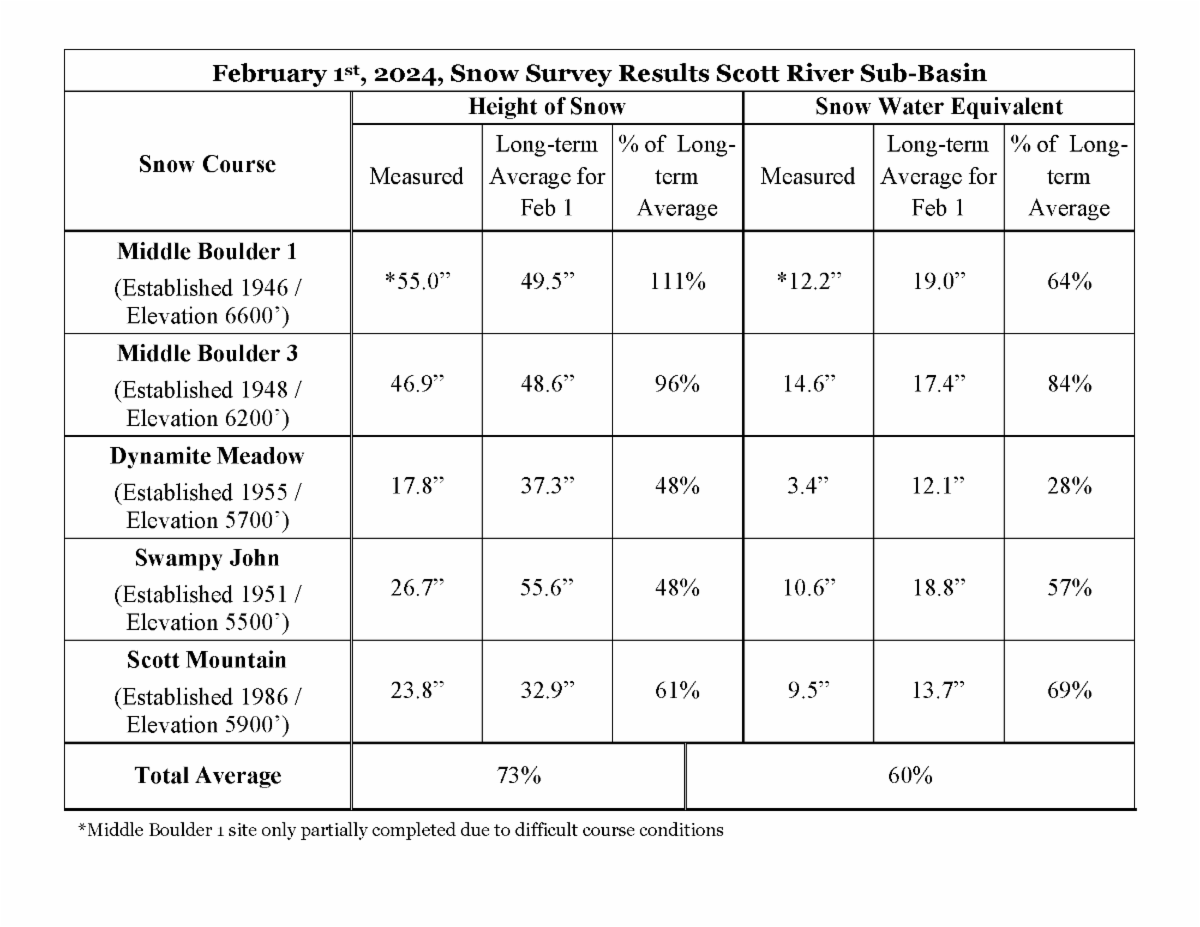
The month of January began with a nice accumulation of snow, but a shift to warmer weather mid-month, including rain at higher elevations, resulted in on-the-ground snow conditions reminiscent of March or April. While the atmospheric river at the end of January did add more snow to the mountains around the Scott River Valley, most significant additions were at the higher elevations. According to measurements taken for the February survey, the snowpack is at 73% of the historic average snow height (snow depth) and at 60% of the historic average Snow Water Equivalent (SWE, a measure of water content) across all survey points (see result table). Historically, snowpack reaches its annual maximum by late-March/early-April.
Of note, survey crews were only able to complete part of the Middle Boulder 1 course (5 of 10 planned holes) due to very difficult sampling conditions including ice layers, voids, and highly compressible snow.
Snow surveys are conducted monthly during the winter and spring months (February through May). Forest Service employees travel to established sites in the headwaters of the Scott River watershed to take measurements. The newest measuring site at Scott Mountain has been monitored for over thirty-five years; the oldest site at Middle Boulder has been monitored for over seventy years. Some sites are located close to Forest roads with good access, while others require hours of travel by snowshoe and/or snowmobile.
The height of snow and Snow Water Equivalent (“SWE”, measure of water content) are measured by a snow sampling tube with a cutter end that is driven through the snowpack, measuring depth. The snow core is then weighed to determine the water content (SWE). The information is forwarded to the State of California, where the data is compiled with other snow depth reports and becomes part of the California Cooperative Snow Surveys program. The data is managed by the California Department of Water Resources; more information is available on their website at http://cdec.water.ca.gov/snow/current/snow/index.html
- Writing Classes and Contests – John SammonPost Views: 62 By John Sammon “My advice if you’re thinking about taking a writing class in an effort to become a novelist or entering a writing contest is—-let the buyer beware.” I have to admit I am not a fan of either. First of all, often enough both will cost you money, a class
- Loose Screws: Mount Shasta Leadership Shakeup Leaves Questions UnansweredPost Views: 876 By J.A. MartinSiskiyou News Mount Shasta City Council took swift action on July 8: placed City Manager Todd Juhasz on indefinite paid administrative leave and replaced City Attorney John Kenny with interim attorney Andrew Jared of Colantuono, Highsmith & Whatley, PC. At the July 13 meeting, Mayor Casey Glaubman cited fiduciary duty and legal restrictions: the council cannot publicly discuss employment or
- Protecting Your Health During A Wildfire : What Northern California Residents Should KnowPost Views: 84 By: Dr. Dinelli Monson, Chief Medical Officer, UnitedHealthcare Employer & Individual Plans of California A wildfire can change daily life quickly in Northern California when residents face smoky skies, reduced air quality, and the possibility of evacuation during periods of elevated wildfire activity. While conditions may look different from one community to
- State Water Board To Consider LOW-INTEREST LOAN For Quartz Valley Tribe Land Acquisition In Scott River HeadwatersPost Views: 105 CWSRF financing would fund tribal land-back effort aimed at watershed restoration and salmonid habitat protection ETNA — The State Water Resources Control Board is scheduled to consider a resolution at its July 21 meeting that would authorize a low-interest loan to the Quartz Valley Indian Reservation (QVIR) to acquire and protect land in
- Obituary: Minnie “Bunny” FrederickPost Views: 57 Minnie “Bunny” Frederick died on July 10, 2026 at her home in Yreka. She was born on February 9, 1926 in CleElum ,Washington to Robert and Minnie Ballard. Bunny had two sisters: Betty and Babs, and two brothers: Chuck and Bobby, all of whom preceded her in death. Bunny had to quit