Siskiyou, South County, Yreka

IR Mapping Discovers 27 Acre Fire In Siskiyou Crest Biological Area

The USDA Forest Service National Infrared Operations (NIROPS) Unit using high resolution airborne infrared imagery and fire detection data to infrared interpreters. The timely availability of acquired imagery and derived data enables infrared interpreters to generate tactical scale fire mapping that support situational awareness and informed decision-making by incident command teams.


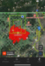
On mapping the #McKinneyFire a hot spot was locate 2 miles south of the California Oregon Border and 8 air miles west of Hilt, California.


The Fires location is the Blue dot..–>


The Map is from my phone using ONX mapping app that allows me to down load maps when I do not have cell coverage. After the morning briefing I teamed up with operations to go and try to photograph the great work being done in the Siskiyou Crest Botanical Area.


The Yreka phlox is a perennial, low-growing bright rose-pink to white-flowered plant that grows in soils derived from ultramafic parent materials (igneous rock containing high concentrations of iron and magnesium) in and near the City of Yreka, Siskiyou County, California. This species has a very limited distribution and may be at particular risk from human land use activities, such as housing development and road construction, as well as catastrophic natural events, such as disease or fire.


Long-term survival of Yreka phlox is dependent upon protecting and securing known occurrences of this species.

This 5-year review summarizes the significant progress that has been made to understand, recover, and conserve Yreka phlox.


Photo by USFWS Yreka Fish & Wildlife Office

https://www.fws.gov/species/yreka-phlox-phlox-hirsuta


The IC "incident command" ordered

  • 10 Engines

  • 4 Hand Crews

  • 5 Water Tenders

  • and all available aircraft

Great care and emphasis was taken to get this fire quickly under control and extinguished.


In the video the CalFire dozer operator used finesse to climb the bank and tread lightly with such a powerful earth moving machine.


IC bings in the profressional in the trade, was great to see local knowledge and skills being utilized.


My PIO "Public Information Officer" Daniel Lending a hand.


KNF Engine E316 Pumping to a hose lay

900 feet up the hill with 300 PSI.


Hand crew headed up the hill, each firefighter packing 150 feet of hose and gear! Afraid to ask how heavy that pack is with tools and safety gear.


Having a Medic is also essential for fire line operations and firefighter

medical needs if the

situations arises.


Fill that portable tank!


Steve Poling, Assistant Fire chief for Scott Valley Fire Protection Filling the Portable tank so the pumper engine stays supplied with water for the hand crews on the line.


Sadly I was not able to get up on the fire line, the scene was not safe for me and I honored the decision of the incident commander. It was a real honor to be invited to photograph the operation. The fire is reported to be contained with fire hose around the 27 acre perimeter. The smoke cleared enough to get helicopters assisting with interior hot spots.


Great work was done by CalFire, U.S. Forest Service, and local fire support on this fine day protecting a very special and sensitive area in Siskiyou County.


Photos By Jay Martin

Siskiyou News Publisher


Comments are closed.