
Per Authors request: “Please only post citations or reference material on the question of whether or not a 31-foot barrier impassable by salmon existed prior to construction of Copco Dam.
Author: Zachary Royce
Multiple Image Sources
I will start with the information posted by William Simpson II (which I have separately called misinformation) and proceed with several of my own items of evidence, gathered in years of research writing a book about this area, and a solid year of writing a book about the building of Copco dam. To be sure my own information (and Simpson’s original claims) do not get lost.

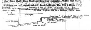
This is the evidence repeatedly provided by William Simpson II in support of his claim that a continuous 31-foot sheer waterfall impassable by salmon exists just above Copco Dam. Discounting all the evidence that follows, I argue this evidence is deficient in itself because it only shows an “elevation” view of the obstruction from the side, not an overhead “plan view” or an in-line “elevation” or a “cross-section” detail of the lowest point. Without these other views, Boyle’s diagram could represent a V-notch, a staircase ascendable by salmon, a geological map for foundation studies, etc. This is common knowledge to people who deal with building plans, that you need these different views to understand the building shape.
To be fair to William Simpson II, here is a quote from his latest post pushing this theory. Simpson has been representing himself as a well-researched advocate for Klamath Basin irrigation interests and the related issues of dams, salmon, etc. People in Siskiyou County trust that he is a diligent and knowlegeable researcher. Perhaps they were misled. Here’s his words:
“I again direct everyone’s attention to John Boyle’s carefully illustrated drawing showing >Clammittee Lake< Filled To the Crest of the 31-foot tall basalt lava dam (one of five lava dams that completely blocked the Klamath River in the Wards Canyon reach according to Texas A&M Geology Department. And as we examine Boyle’s drawing, he also depicted a Waterfall into the shallow river bed below the basalt dam. IF what Royce is trying to argue was true, Clammittee Lake wouldn’t be spilling Over the top of the lava dam… and moreover, these huge vertical lava dams provide a scientific explanation for the known ‘speciation’ of salmonids we see in the upper Klamath Basin, which requires a physical barrier to cause an otherwise homogenous species to diverge genetically, and as we see in the case at hand, we have non-fluvial Red Band Salmon-trout, and the fluvial salmon that existed below Nature’s dams in the Klamath Basin. IF salmon actually were swimming all the way up to Klamath Falls as some ‘experts’ posit, the Klamath Tribe would have, without any doubt, have had Salmon Ceremonies and Totem to Salmon, which they never had… They only had ceremonies and totem for the sucker fish. This is hugely telling, because up and down the entire west coast to Alaska tribes, salmon being a ‘first food’ and commercially important for trade, were always celebrated via ceremony and totems. Again, anthropological and cultural archaeological research show no salmon ceremonies or totem attributed to the Klamath Tribes. The Klamath traded with the Shasta Tribe to get their salmon, Chief Roy Hall told me that face to face. End of Debate!”


There are two spurs coming in from the right (left bank of river). The foremost is being used here for a diversionary dam, to direct the river into a diversionary tunnel located just behind it, between the two spurs. I think it is possible that the white stripe is the high water line of “Clammite Lake” in Boyle’s diagram. You will notice no vegetation. I think the white is from diatomic dust, present everywhere around the shore of Copco Lake. Boyle Collection, SOHS. It is a few feet higher than the level of the obstruction here covered with fill and diversionary dam, which might have been rock before. Thus it is possible that prior to alterations to this work site that the obstruction formed here was a few feet higher. This is not evidence that it blocked salmon. We don’t know what the total height over the next previous step is (the obstruction could be sloped like a spur or staircase, or similarly with boulders and gravel. The fact that the white strip exists on the downstream end of the upstream spur shows that the two spurs were never in fact one spur, insofar as this white line represents a former “Clammite Lake.” We know that salmon ascended upstream of here for other reasons, cited below.
The fall of the river at this point is about 200’/ft, thus the lake would only extend a short distance upstream. We can see that it doesn’t extend beyond the mouth of Ward’s Canyon by the rapids in the photo of the entrance of Ward’s Canyon that follows below, as well as the various maps and photos showing a river not a lake where Copco reservoir was.

Copco Dam under construction c. 1917. Note the shape of the concrete footing so you can identify the breach hole in another photograph. Note the location of the diversionary dam in foreground. There is a smaller rapid below the diversionary dam, further indication of a staircase shape to this whole section leading to and under the dam. Boyle Collection, SOHS.

This is about 1000 feet upstream of Copco Dam. We are looking down the long “straight” before the first dog leg, created by the upstreammost of the two spurs earlier referred to on the left bank. Thus we can not see the second spur (site of the diversionary dam) or future Copco 1 location. It is helpful to understand this stretch as two straights connected by a dog-leg and its return. It helps us know that we are seeing the whole picture when going back and forth between overhead maps and photos. Notice the rapid in foreground. This establishes that any “Clammite Lake” existing downstream prior to dam construction did not extend to the upstream entrance to the canyon.

You are looking at the remains of the diversionary dam and, I argue, whatever is left of the obstruction in Boyle’s diagram. A “diversionary dam” as I use it here is a dam entirely across a stream diverting it into a “divesionary tunnel.” The diversionary dam is evidently constructed over a spur of rock with rock fill, or that is solid rock poking in from the left bank. There is a bridge built to that spur from the right bank. There is a a rock crib built at the end of the spur to receive the bridge, and divert water around it. A rock crib is a timber-walled structure filled with rock to weigh it down. A “coffer dam” is a dam around an excavation area. Sure, the remains of man-made construction you see formed part of a structure that was used to excavate a cleared section of riverbed. But the canyon walls and the spur form part of that “coffer dam” as well as the lower foundation of Copco1. I have provided a number of photographs that should show this diversionary dam from different angles. Please let me know if something is still not clear.


You can see the dog leg/return and the two spurs right in the middle of it, interfering with the channel yes, but forming something like a V-notch, not a continuous 31-ft waterfall.

This shows the new demolition tunnel on the left and the old diversionary tunnel exit on the right. The demo tunnel is 14′ diameter at opening, narrowing to 10′. It does have downward downstream pitch like a low-pitch roof.

The lava flow you see is about two miles long. It came from the line of cinder cones you see in a north-south line intersecting the river near the upper end of the lava flow (the lava flowed mostly downhill). This dammed the larger Klamath River canyon and formed natural lake somewhat larger than Copco Reservoir. Ward’s Canyon was worn through this obstruction until the lake behind it was entirely drained except for the river bed. This big two-mile lava flow that dammed the canyon is young lava. The andesite “reef” that Boyle’s speaks of is below this lava–a spur of it runs through the river at about Copco Dam. We also see it peeking out from the southern part of the lava flow, and north of the river at Sloan’s Butte and Fall Creek Falls.


William Simpson II likes to castigate me for supposedly being an idiot carpenter contradicting engineer Boyle. I have never contradicted Boyle. But here is an excellent instance of William Simpson II contradicting Boyle, from Boyle’s “Fifty Years on the Klamath” (page 9). Jake is fishing at the first projected dam site at the upstream entrance to Ward’s Canyon.


Cross section of river beneath Copco 1 Dam showing V-notch shape bedrock base going ~130′ below river bed of gravel and boulders. They filled all this in with concrete for a solid footing. This is Sheet H25, Section A-A from Boyle’s 1912 plans, copied in his “Fifty Years on the Klamath.”
*reprinted with Zachery Royce permission, fb source: https://www.facebook.com/groups/384246450824754/permalink/395451806370885/?mibextid=oMANbw
- Obituary : Betty Jane CliffordPost Views: 19 Longtime Siskiyou County resident, Betty Jane Clifford, passed away peacefully on Saturday, June 27, 2026 at her Yreka home. She was 91 years old. Betty was born Betty Jane Richert on February 17, 1935 to Roland and Alice (Roettger) Richert in Baytown, Minnesota. She had two older sisters, Alice and Florence. When
- FICTITIOUS BUSINESS NAME STATEMENT – SISKIYOU NEWS LLCPost Views: 25 Filing No.: 2026-47-0216FILED IN: Siskiyou CountyDATE: Jul 02 2026LAURA BYNUM, ClerkBy: E. FRANCO,Deputy ClerkFICTITIOUS BUSINESS NAME STATEMENTThe following person (persons) is (are) doing business as:SISKIYOU NEWS LLC206 Main StrettEtna, CA 96027 in SiskiyouMailing Address:206 Main StreetEtna, CA 96027(530)643-1050Registered Owner(s):Jay A. MartinThis Business is conducted by: A Limited Liability Company , State of
- Notice of Petition to Administer Estate of KARL RALPH MAJESKYPost Views: 23 Notice of Petition to Administer Estate of KARL RALPH MAJESKYCASE NUMBER 26PB10553To all heirs, beneficiaries, creditors, contingent creditors, and persons who may otherwise be interested in the will or estate, or both of KARL RALPH MAJESKY.A Petition for Probate has been filed by ROBIN BALMER in the Superior Court of California, County
- Civil Grand Jury Report: WHETHER A VACANCY HAS OCCURRED ON THE YREKA CITY COUNCILPost Views: 479 SISKIYOU COUNTY CIVIL GRAND JURY CIVIL TERM: 2026 Dawnmarie Autry and Lorenzo Love were recused from every part of this report. SUMMARY The Siskiyou County Civil Grand Jury investigated whether a vacancy occurred when a Councilmember in Question’s absence from all regular Yreka City Council meetings for 62 consecutive days between October
- Grand Jury Report: Siskiyou County Jail Too old, too under fundedPost Views: 798 2025–2026 Siskiyou County Civil Grand Jury Report Summary Too old, too overcrowded, too undermanned, inadequate funds for maintenance. The Jail Commander and his staff do an outstanding job running an operation crippled by overcrowding and a lack of funding for basic maintenance. Background The Siskiyou County Jail is the backbone of the

3 Comments
Final Nail in Mr. Royce’s Coffin: https://www.youtube.com/watch?v=1S0d8INhvpA
Royce is serving up a sloppily made baloney sandwich… Read the facts to blow his assertions out of the water: https://drive.google.com/…/1JGs2LMD1ehOKegIMNr2…/view…
DRIVE.GOOGLE.COM
HamiltonCharts.pdf
This information debunks the foundational argument and closing posit by Mr. Royce: https://drive.google.com/file/d/1JGs2LMD1ehOKegIMNr2K5sSLU0AkGxdb/view?fbclid=IwAR2j2RuOHbJXD6ckWVsjLkYSBVhTrBdsax9GdhthpB9HKOOZVfTiEI_UqI8